Le Malpas
Le Malpas
During three field seasons, between 1967 and 1969, we uncovered a series of archaeological layers attributed to the Solutrean (20-18,000 years ago) and the Late Gravettian (28-24,000 years ago) phases of the Upper Paleolithic. The locality had been surveyed and recorded as a late Paleolithic (Magdalenian or Solutrean) site.
The excavations were supported by grants from the National Science Foundation (GS 2444 and GS3174).
Landscape
Occupied by Neandertals during the Middle Paleolithic (see Combe Capelle), the Couze Valley, a tributary of the Dordogne River, became a favored territory of Cro Magnon groups. The sites of Le Colombier, La Gravette, Les JeanBlancs, Patary, Combe Capelle, Termo Pialat cluster along the south facing cliffs of the Couze.


The Site
Located close to Les JeanBlancs, but on the northern bank of the the Roumaguet, Le Malpas was well situated to serve as a look out. From the edge of the terrace Paleolithic hunters were able to follow the migration of game herds up and down the ravine in their seasonal migrations between valley and uplands. The terrace provided a flat living surface protected by the cliff from dominant winds, and large flint nodules outcrops on the slope provided a source of raw material for tool making.
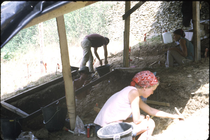
When we arrived at the site, the terrace was almost completely cleared of Ice Age deposits. However, traces of consolidated sediments with prehistoric flint tools were still attached to the cliff wall, indicating that at least one meter of deposits with rich archaeological layers had once rested on the terrace. The terrace at the foot of the cliff must have been a major occupation site in Paleolithic times. Limestone quarries, opened in Medieval times to extract stones needed for the construction of nearby castles, destroyed, or at least displaced, the Pleistocene sediments which would have contained abundant prehistoric remains. In the late nineteenth or early twentieth century a sheep pen was built on the terrace. Stone walls were erected across the slope to create man-made terraces to grow fruit and vegetable crops. As a result of all these activities, the sediments and their archaeological content were removed from the terrace and dumped on the slope where they formed a thick layer of topsoil containing large quantities of displaced stone artifacts.
However, testing done in 1967 at the onset of the project uncovered two areas where there remained relatively extensive and intact Pleistocene deposits. They were designated Le Malpas West (LMW), under the terrace at the top of the slope, and Le Malpas East (LME) at the eastern extremity of the terrace.


Le Malpas West
Once the topsoil was removed from an area of the slope immediately below the terrace, we uncovered a surface of consolidated deposits containing reindeer bones and stone artifacts clearly undisturbed by human hands. The opening of two small trenches in 1967, enabled us to recognize the presence of two meters of deposits in place. Bones were relatively rare, but flint artifacts were abundant in the top 60-70 cm of the deposits. Work continued in 1968, extending the excavations to squares adjacent to the 1967 trenches.
Work continued in 1968 in square units adjacent to the initial trench. The archaeological levels formed a 50 to 60 cm thick, indurated level at the top of the deposit sequence. A deeper trench dug down to bedrock showed that the lower series of sediments contained no archaeological remains.


When was Le Malpas West Occupied?
We recovered finely made, bifacial point fragments from the archaeological layers, which identified the layer as Solutrean, a cultural phase known from other sites in the region to date between 20,000 and 18,000 years ago.
That 2000 years period corresponds to the last major advance of the glaciers over Scandinavia and Northern Europe (LGM). Living conditions would have been harsh at the time — how harsh is what we wanted to find out.
Columns of sediment samples were taken from the exposed wall of the main trench. J.P. Texier conducted the studies of the sediments and M.M. Paquereau that of the pollen samples at the University of Bordeaux (France). R. Rogers and L. Martin analyzed the animal remains at the University of Kansas. We took the results of the identification of the pollens and small mammals as the best indicators of climatic and environmental conditions at the site at the time it was occupied.


Vegetation of the Couze Valley at the time of occu
As a whole the climate appears to have been much colder than at present with notable variations in humidity. The dominant landscape was cold steppe with clumps of trees. Deciduous trees disappeared completely at times during colder periods, with only pine and juniper resisting. However they returned rather rapidly as humidity increased. In geological terms, climatic oscillations were relatively short term and changes were rapid.
A multivariate analysis (principal components) was performed using the frequency of identified pollen grains for every level in the sequence. Results of the analysis are summarized in two graphs. The graph on the left shows groups of trees, brushes, and grasses that constituted vegetation communities at the site. The graph on the right displays the frequency of these communities for all levels placed in stratigraphic sequence. The zigzag lines reflect climatic changes through time based on the presence or absence of various species of trees and plants. The negative values associated with milder or at least more humid conditions are associated with levels 1, 3, 6 and 9. The positive values indicative of colder and dryer environments characterize levels 2, 4, 7, and 8. Paleolithic people occupied the site during the formation of level 5, 4, 3, 2, and 1, which represent a period of relatively short and rapid climatic changes.


Le Malpas East
A determined and enterprising student member of the crew, Richard Rogers, kept working at the eastern edge of the terrace, hoping to find archaeological layers still in place under the very solidly indurated deposits still attached to the cliff wall. His efforts were successful and led to the excavation of several living floors with unusual features that bring some light on the manner in which Late Paleolithic people cooked and lived around their fireplaces.
The main living floor feature was associated with the lowest layer, which rests immediately on the bed of platelets formed above the limestone bedrock. It was a huge firepit dug into the layer of platelets and filled with black ash and small fragments of animal bones. Behind the pit was a small basin shaped depression surrounded by limestone slabs. This curious and complex structure was probably used for cooking and roasting meat. Ash dumps were recovered nearby, suggesting that the pits were cleaned and reused a number of times.


Archives
Archives and collections from the site are located at the Musée National de Préhistoire Les Eyzies-de-Tayac in Les Eyzies-de-Tayac, Dordogne, France.
Data
Data files in preparation.
Publications
Le Malpas Rockshelter by Anta Montet-White with chapters by M.-M. Paquereau, R. Rodgers, and J.-P. Texier, University of Kansas Publications in Anthropology No. 4, 1974.
The book can be ordered from the Anthropology Department, Frazer Hall, The University of Kansas, Lawrence, KS 66045, USA